Rendered at 16:40:46 10/08/25


Sign up and get $5.00 bCredits free to use at checkout and another $5.00 bCredits when you make your first purchase. More info
Envío gratis
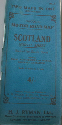
Bacon’s Motor Road map of Scotland, Two Maps in One, Produced Printed and Publis
€17,20 EUR
Sign up and get $5.00 bCredits free to use at checkout and another $5.00 bCredits when you make your first purchase. More info
Los buques de
United States

Share & earn! Sign in, share this or any listing, and you’ll get commission when it sells.
Learn more
Las opciones de envío
GRATIS en Europe
Los buques de
United States
La política de devoluciones
Protección de compra
Opciones de pago
PayPal accepted
PayPal Credit accepted
Venmo accepted
PayPal, MasterCard, Visa, Discover, and American Express accepted
Maestro accepted
Amazon Pay accepted
Nuvei accepted
Rasgos del artículo
| Categoría: | |
|---|---|
| cantidad disponible: |
Sólo uno en stock, para muy pronto |
| Condition: |
Very Good |
| Type: |
Road Atlas |
| Format: |
Folding Map |
| Country: |
Scotland |
| Special Attributes: |
1st Edition, Poster |
| Language: |
English |
| Country/Region of Manufacture: |
Great Britain |
| Author: |
Bacon's |
| Region: |
Scotland |
Detalles del anuncio
| Envío de descuento: |
Vendedor paga el envío para este artículo. |
|---|---|
| Precio de descuento: |
10% De descuento w / $100.00 pasó |
| Publicado en venta: |
Más de una semana |
| Artículo número: |
1741516298 |
Descripción del Artículo
Paper folded 27 sections reversible colour map in green card covers. Opens to an impressive 40'' x 30''. Scale 8 miles to 1 inch. Showing roads, distances and railways. One tear to one-fold. Priced 4/- to the front cover. Member of the P.B.F.A. CARTOGRAPHY, MAPS, PLANS
Added to your wish list!

Get an item reminder
We'll email you a link to your item now and follow up with a single reminder (if you'd like one). That's it! No spam, no hassle.
Already have an account?
Log in and add this item to your wish list.