New York City 75-Mile Radius Wall Map and 36 similar items
Envío gratis
New York City 75-Mile Radius Wall Map
€318,80 EUR
(Buy a Up to 30% discount card for $30.00 first, and you will save $48.26 on this item and get up to 30% off future purchases for the next 3 months.
Unlock the discount with just a few clicks - start here)
Share & earn! Sign in, share this or any listing, and you’ll get commission when it sells.
Learn more
View full item details »

Las opciones de envío
Los buques de 10 business days Detalles
No hay precio de envío se especifica en ES
Los buques de
United States

La política de devoluciones
Replacement product available within 30 days
Detalles
Protección de compra
Opciones de pago
PayPal accepted
PayPal Credit accepted
Venmo accepted
PayPal, MasterCard, Visa, Discover, and American Express accepted
Maestro accepted
Amazon Pay accepted
Nuvei accepted
View full item details »
Las opciones de envío
Los buques de 10 business days Detalles
No hay precio de envío se especifica en ES
Los buques de
United States
La política de devoluciones
Replacement product available within 30 days
Detalles
Protección de compra
Opciones de pago
PayPal accepted
PayPal Credit accepted
Venmo accepted
PayPal, MasterCard, Visa, Discover, and American Express accepted
Maestro accepted
Amazon Pay accepted
Nuvei accepted
Rasgos del artículo
| Categoría: | |
|---|---|
| cantidad disponible: |
Sólo uno en stock, para muy pronto |
| Condition: |
New |
| Country/Region of Manufacture: |
United States |
Detalles del anuncio
| Las políticas del vendedor: | |
|---|---|
| Publicado en venta: |
Más de una semana |
| Artículo número: |
1744962974 |
Descripción del Artículo
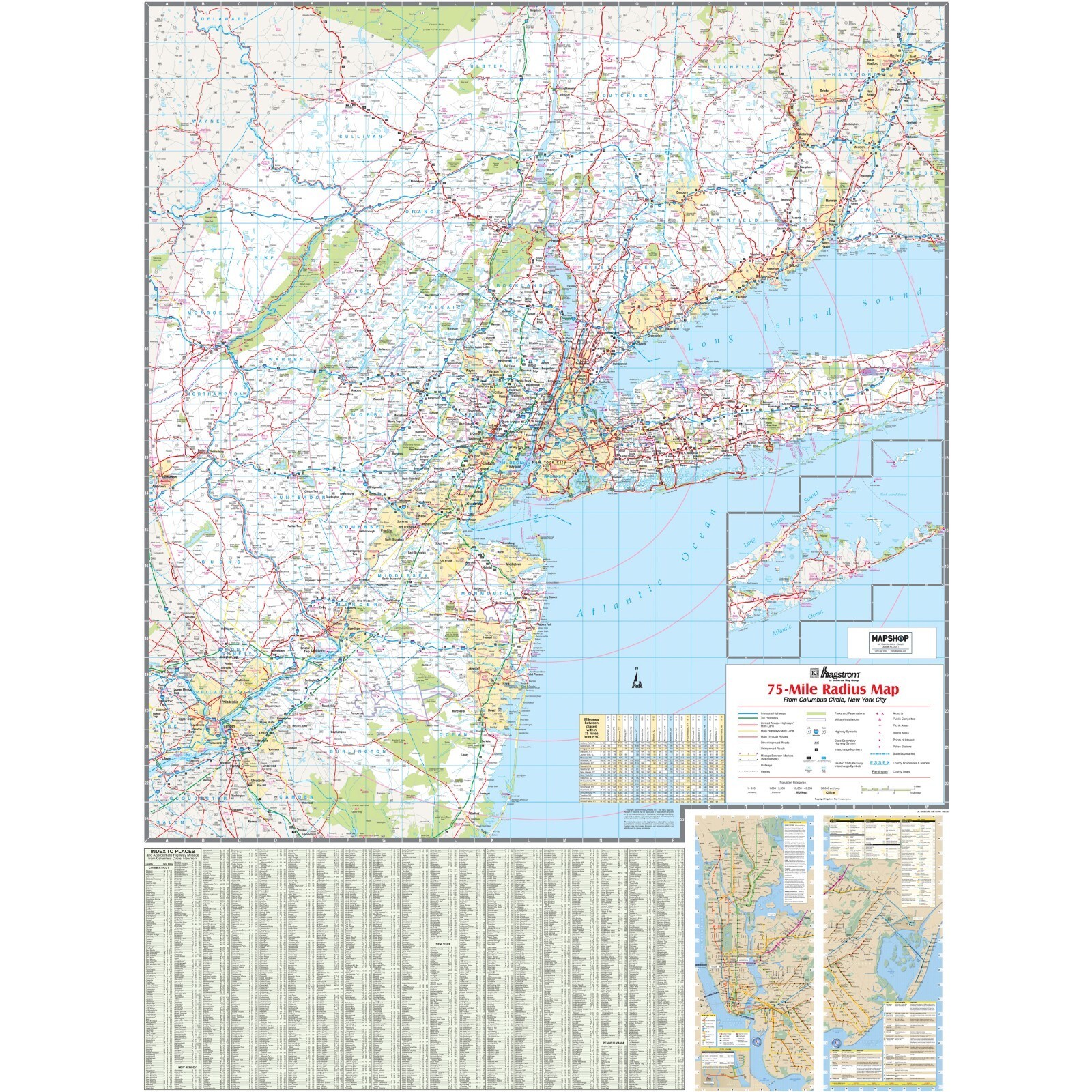
New York City 75-Mile Radius Wall Map
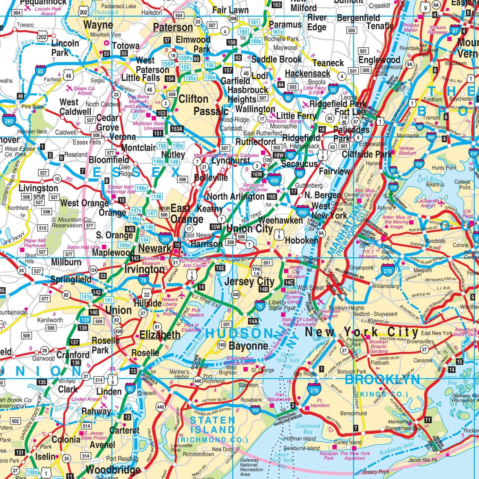
The New York City 75-Mile Radius Tri-State Area Regional Wall Map is an expansive map that provides a detailed view of the New York City metropolitan area and surrounding regions, extending into New Jersey, Connecticut, and Pennsylvania. It highlights an extensive road network, featuring major highways, toll roads, and other significant routes, facilitating travel planning and navigation within one of the most densely populated areas in the United States. The area of coverage includes the following:
Nassau, Orange, Putnam, Rockland, Suffolk, and Westchester Counties, and portions of Duchess and Ulster Counties, in New York
Airfield, Litchfield, and New Haven Counties, and portions of Hartford and Middlesex Counties, in Connecticut
Bergen, Essex, Hudson, Hunterdon, Mercer, Middlesex, Monmouth, Morris, Passaic, Somerset, Sussex, and Warren Counties, and portions of Burlington and Ocean Counties, in New Jersey
The map covers an area with the following boundaries:
North to Waterbury, CT; Poughkeepsie, NY; and Hartford, CT
South to Philadelphia, PA; and Stafford, NJ
East to Montauk Point, NY; and New Haven and Hartford, CT
West to Allentown and Bethlehem, PA
The map includes a comprehensive index of towns and cities, which is detailed along the bottom edge, aiding users in locating specific areas. Insets of the map focus on high-density regions, providing a more granular look at the intricate urban roadways. A 75-mile radius circle centered on New York City is clearly marked, giving context to the map?s scope. Additional information such as a mileage chart for estimating distances between key locations is included, and a legend defines the symbols and color codes used to denote various types of infrastructure and points of interest. This map is a resourceful guide for residents, businesses, and visitors, offering detailed geographic information for a significant portion of the Tri-State area.
|
Why are we showing these items?
Booth
Rockford Map Gallery |

|


 - €39,95 EUR")


-
Refine your browsing experience
We can show you more items that are exactly like the original item, or we can show you items that are similar in spirit. By default we show you a mix.
Este artículo ha sido añadido a su carrito
 New York City 75-Mile Radius Wall Map added to cart.
Único disponible en stock
New York City 75-Mile Radius Wall Map added to cart.
Único disponible en stock
Ver el carro o seguir comprando.
 Por favor, espere mientras termine de agregar este artículo a su carrito.
Get an item reminder
We'll email you a link to your item now and follow up with a single reminder (if you'd like one). That's it! No spam, no hassle.
Already have an account?
Log in and add this item to your wish list.