Rendered at 21:43:19 05/19/25


Envío gratis
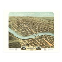
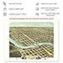
HISTORIX Vintage 1869 Kankakee Illinois Map Poster - 18x24 Inch Old Map of Kanka
€35,72 EUR - €49,12 EUR
Los buques de
United States


Las opciones de envío
Los buques de 2 business days Detalles
No hay precio de envío se especifica en ES
Los buques de
United States
La política de devoluciones
Full refund available for DOAs
Detalles
Protección de compra
Opciones de pago
PayPal accepted
PayPal Credit accepted
Venmo accepted
PayPal, MasterCard, Visa, Discover, and American Express accepted
Maestro accepted
Amazon Pay accepted
Nuvei accepted
Rasgos del artículo
| Categoría: | |
|---|---|
| cantidad disponible: |
16 En stock |
| Condition: |
New |
| Color: |
Brown |
| ASIN: |
B0BT7K26SV |
| Bullet Point: | |
| Product Description: | |
| Brand: |
HISTORIX |
| Supplier Declared Dg Hz Regulation: |
not_applicable |
| Item Name: | |
| Item Type Keyword: |
prints |
| Product Site Launch Date: |
2023-01-27T07:59:32.675Z |
| sizes: |
Detalles del anuncio
| Las políticas del vendedor: | |
|---|---|
| Envío de descuento: |
Vendedor paga el envío para este artículo. |
| Publicado en venta: |
May 1 |
| Artículo número: |
1743606997 |
Descripción del Artículo
Produced and published by one of the most prolific cartographers of the bird's eye perspective genre, Albert Ru ger, this detailed panoramic map illustrates Kankakee in a period of significant growth and transition in the years following the conclusion of the American Civil War. Kankakee became an important anchor city in the rural plains surrounding the Chicago area. The town was founded in 1854, and this depiction marks the region's development through those years as manufacturing and its proximity to Chicago made the area a popular destination for residents looking to relocate from the American South as well as Western and Northern Europe.
Kankakee is situated at the confluence of the Iroquois and Kankakee rivers, which were essential trading routes during the early portions of the nineteenth century. The region experienced a significant increase in population during the latter parts of the 1800s as economic opportunities expanded and access was made possible with the establishment of rail lines across the North and Western United States. Kankakee is home to two iconic homes designed by notable architect Frank Lloyd Wright. The B. Hardey Bradley House and the Warren Hickox House which still stand to this day.
Albert Ru ger was a pioneer of the bird's eye perspective style, and his works are widely regarded as influencing the style, which became incredibly popular from the mid-nineteenth century until the 1920s when advances in aerial photography made the form obsolete. These highly stylized pieces of cartographical history immediately transport the viewer back in time.
Additional Details
------------------------------
Bullet point: VINTAGE MAP REPRODUCTION: You?ll love this high quality historic reproduction of 1869 Kankakee Illinois Map Poster. Our museum quality prints are archival grade, which means it will look great and last without fading for over 100 years. Our print to order maps are made in the USA and each map is inspected for quality. This beautiful artwork is a perfect addition to your themed decor. Vintage maps look great in the home, study or office. They make a perfect gift as well.
Product description:
Produced and published by one of the most prolific cartographers of the bird's eye perspective genre, Albert Ru ger, this detailed panoramic map illustrates Kankakee in a period of significant growth and transition in the years following the conclusion of the American Civil War. Kankakee became an important anchor city in the rural plains surrounding the Chicago area. The town was founded in 1854, and this depiction marks the region's development through those years as manufacturing and its proximity to Chicago made the area a popular destination for residents looking to relocate from the American South as well as Western and Northern Europe.
Kankakee is situated at the confluence of the Iroquois and Kankakee rivers, which were essential trading routes during the early portions of the nineteenth century. The region experienced a significant increase in population during the latter parts of the 1800s as economic opportunities expanded and access was made possible with the establishment of rail lines across the North and Western United States. Kankakee is home to two iconic homes designed by notable architect Frank Lloyd Wright. The B. Hardey Bradley House and the Warren Hickox House which still stand to this day.
Albert Ru ger was a pioneer of the bird's eye perspective style, and his works are widely regarded as influencing the style, which became incredibly popular from the mid-nineteenth century until the 1920s when advances in aerial photography made the form obsolete. These highly stylized pieces of cartographical history immediately transport the viewer back in time.
Added to your wish list!

- HISTORIX Vintage 1869 Kankakee Illinois Map Poster - 18x24 Inch Old Map of Kanka
- 16 in stock
- Available in multiple sizes
- Handling time 2 day.
- Returns/refunds accepted
Get an item reminder
We'll email you a link to your item now and follow up with a single reminder (if you'd like one). That's it! No spam, no hassle.
Already have an account?
Log in and add this item to your wish list.