Rendered at 12:11:02 05/28/25


Envío gratis
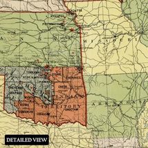
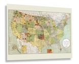
HISTORIX Vintage 1892 Indian Reservations Map Poster - 18x24 Inch Old Map of Ind
€35,21 EUR
Los buques de
United States


Las opciones de envío
Los buques de 2 business days Detalles
No hay precio de envío se especifica en ES
Los buques de
United States
La política de devoluciones
Full refund available for DOAs
Detalles
Protección de compra
Opciones de pago
PayPal accepted
PayPal Credit accepted
Venmo accepted
PayPal, MasterCard, Visa, Discover, and American Express accepted
Maestro accepted
Amazon Pay accepted
Nuvei accepted
Rasgos del artículo
| Categoría: | |
|---|---|
| cantidad disponible: |
8 En stock |
| Condition: |
New |
| MPN: |
ENMAP06821824 |
| UPC: |
705514890405 |
| EAN: |
0705514890405 |
| Paint Type: |
Watercolor |
| color: |
Natural |
| manufacturer: |
HISTORIX |
| Externally Assigned Product Identifier: |
0705514890405 |
| Item Shape: |
Rectangular |
| Age Range Description: |
Adult |
| Bullet Point: | |
| Product Description: | |
| Brand: |
HISTORIX |
| Unspsc Code: |
60121000 |
| orientation: |
Landscape |
| Item Name: | |
| Item Type Keyword: |
wall-maps |
| size: |
24L" x 18W" |
| Mounting Type: |
Wall Mount |
| Part Number: |
ENMAP06821824 |
| style: |
Modern |
| Wall Art Form: |
art_print |
| Target Gender: |
unisex |
Detalles del anuncio
| Las políticas del vendedor: | |
|---|---|
| Envío de descuento: |
Vendedor paga el envío para este artículo. |
| Publicado en venta: |
Más de una semana |
| Artículo número: |
1735833583 |
Descripción del Artículo
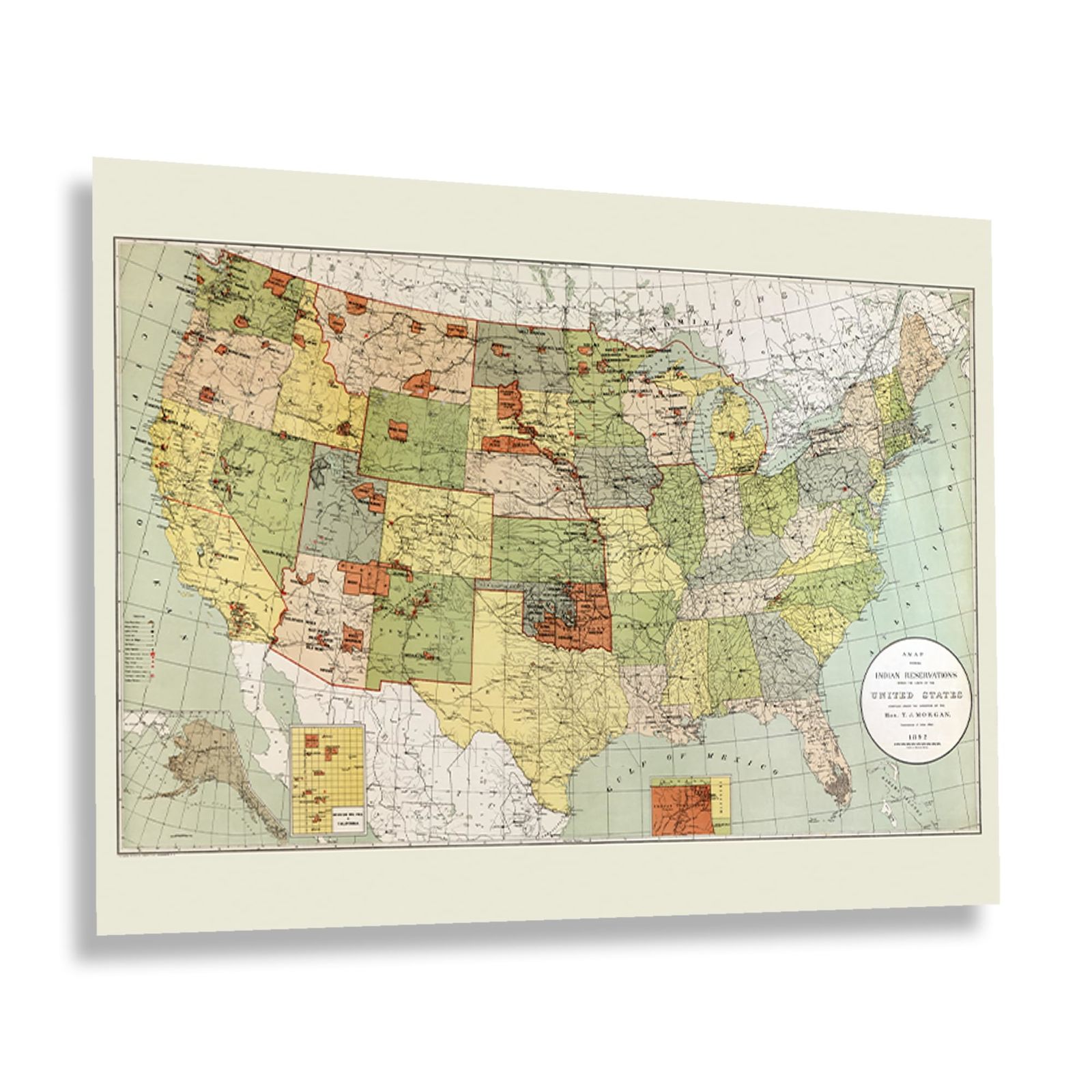
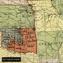
Produced as the nation neared the turn of the twentieth century, this map defines the boundaries of Indian Reservations as the Office of Indian Affairs had drawn them up. This land was allocated under the Dawes Act in 1887, five years before this map’s production. Since the earliest European settlers arrived in North America, Indigenous People were often resettled through treaties and other land ownership legalities. The Office of Indian Affairs was formed in 1824 and was critical to creating these reservations. While they are primarily in the West and Southwest, they were not created along traditional tribal lines, and native populations have declined sharply in the past centuries.
This map bears a distinctive style and bold colors common in the nineteenth century and offers the viewer a glimpse into the past while illustrating how a region has evolved and grown. It was produced by Thomas Jefferson Morgan, who advocated for indigenous people during the time and sought to get them access to modern education. Morgan also fought for Chinese Immigrants and fought to keep discriminatory legislation from being passed by the Federal Government. In 1887, Indian Reservations were no longer to be granted to individuals or single entities in an effort to reduce misrepresentation.
This is an authentic piece of American cartographical history that immediately transports the viewer back in time, creating an indelible bond between the past and present. In recent years, efforts have been made to improve conditions on Indian Reservations.
Additional Details
------------------------------
Bullet point: VINTAGE MAP REPRODUCTION: You?ll love this high quality historic reproduction of 1892 Indian Reservations Map Poster. Our museum quality prints are archival grade, which means it will look great and last without fading for over 100 years. Our print to order maps are made in the USA and each map is inspected for quality. This beautiful artwork is a perfect addition to your themed decor. Vintage maps look great in the home, study or office. They make a perfect gift as well.
Product description:
Produced as the nation neared the turn of the twentieth century, this map defines the boundaries of Indian Reservations as the Office of Indian Affairs had drawn them up. This land was allocated under the Dawes Act in 1887, five years before this map’s production. Since the earliest European settlers arrived in North America, Indigenous People were often resettled through treaties and other land ownership legalities. The Office of Indian Affairs was formed in 1824 and was critical to creating these reservations. While they are primarily in the West and Southwest, they were not created along traditional tribal lines, and native populations have declined sharply in the past centuries.
This map bears a distinctive style and bold colors common in the nineteenth century and offers the viewer a glimpse into the past while illustrating how a region has evolved and grown. It was produced by Thomas Jefferson Morgan, who advocated for indigenous people during the time and sought to get them access to modern education. Morgan also fought for Chinese Immigrants and fought to keep discriminatory legislation from being passed by the Federal Government. In 1887, Indian Reservations were no longer to be granted to individuals or single entities in an effort to reduce misrepresentation.
This is an authentic piece of American cartographical history that immediately transports the viewer back in time, creating an indelible bond between the past and present. In recent years, efforts have been made to improve conditions on Indian Reservations.
Added to your wish list!
- HISTORIX Vintage 1892 Indian Reservations Map Poster - 18x24 Inch Old Map of Ind
- 8 in stock
- Handling time 2 day.
- Returns/refunds accepted
Get an item reminder
We'll email you a link to your item now and follow up with a single reminder (if you'd like one). That's it! No spam, no hassle.
Already have an account?
Log in and add this item to your wish list.