Rendered at 05:29:39 08/03/25


Envío gratis
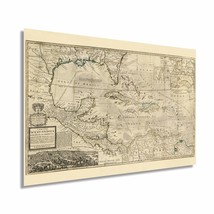
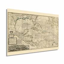
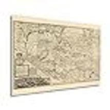
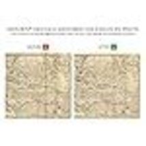
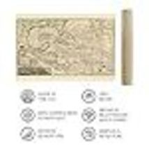
Historix Vintage 1715 Map of West Indies Islands of America - 16 x 24 Inch Vinta
€35,06 EUR
Los buques de
United States


Las opciones de envío
Los buques de 2 business days Detalles
No hay precio de envío se especifica en ES
Los buques de
United States
La política de devoluciones
Full refund available for DOAs
Detalles
Protección de compra
Opciones de pago
PayPal accepted
PayPal Credit accepted
Venmo accepted
PayPal, MasterCard, Visa, Discover, and American Express accepted
Maestro accepted
Amazon Pay accepted
Nuvei accepted
Rasgos del artículo
| Categoría: | |
|---|---|
| cantidad disponible: |
8 En stock |
| Condition: |
New |
| ASIN: |
B08665XYPV |
| Map Type: |
Historical |
| Bullet Point: | |
| Product Description: | |
| Brand: |
HISTORIX |
| Unspsc Code: |
55101500 |
| Item Type Keyword: |
wall-maps |
| Paper Size: |
16 x 24 inches |
| Paper Finish: |
matte |
| Item Name: | |
| Product Site Launch Date: |
2020-03-20T14:43:37.445Z |
| material: |
paper |
Detalles del anuncio
| Las políticas del vendedor: | |
|---|---|
| Envío de descuento: |
Vendedor paga el envío para este artículo. |
| Publicado en venta: |
Más de una semana |
| Artículo número: |
1735773874 |
Descripción del Artículo
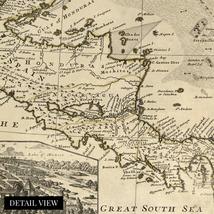
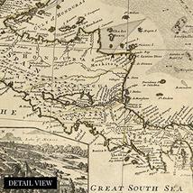
This restored piece or cartographical history comes alive and truly transports the viewer to another time. Pre-dating the American Revolution and harkening back to when the West Indies and Americas were simply disputed territories fought for by the French, Spanish, English and Dutch our restored version of this map shows in stunning clarity the impressive work of early cartographer Herman Moll. Moll was noted for his of Galleon ships and fleets to produce this intricate map that even includes trade winds.
The rich history of this region combined with what was the highest technical ability of cartography at the time, come together to depict a land in flux and evolution. The Americas had been relatively recently discovered and as such were being charted for the first time. The depictions of modern day America and Cuba, as well as Mexico and South America show how truly remarkable the endeavor to colonize these lands was. This map was originally published to distinguish each colonial powers’ claims in the new world and stands out as a testament to Moll’s dedication and expertise.
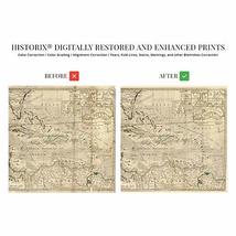
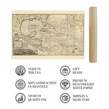
Our museum quality giclee print comes printed with archival ink on premium heavyweight matte paper. Shipped in a sturdy cardboard tube your print will arrive ready to be framed. This eye-catching vintage map reproduction print makes the perfect gift for anyone that loves history and imagery.
Additional Details
------------------------------
Bullet point: VINTAGE MAP REPRODUCTION: You?ll love this high quality historic reproduction of 1715 Map of West Indies Islands of America. Our museum quality maps are archival grade, which means it will look great and last without fading for over 100 years. Our print to order maps are made in the USA and each map is inspected for quality. This beautiful artwork is a perfect addition to your themed decor. Vintage maps look great in the home, study or office. They make a perfect gift as well.
Product description:
This restored piece or cartographical history comes alive and truly transports the viewer to another time. Pre-dating the American Revolution and harkening back to when the West Indies and Americas were simply disputed territories fought for by the French, Spanish, English and Dutch our restored version of this map shows in stunning clarity the impressive work of early cartographer Herman Moll. Moll was noted for his of Galleon ships and fleets to produce this intricate map that even includes trade winds.
The rich history of this region combined with what was the highest technical ability of cartography at the time, come together to depict a land in flux and evolution. The Americas had been relatively recently discovered and as such were being charted for the first time. The depictions of modern day America and Cuba, as well as Mexico and South America show how truly remarkable the endeavor to colonize these lands was. This map was originally published to distinguish each colonial powers’ claims in the new world and stands out as a testament to Moll’s dedication and expertise.
Our museum quality giclee print comes printed with archival ink on premium heavyweight matte paper. Shipped in a sturdy cardboard tube your print will arrive ready to be framed. This eye-catching vintage map reproduction print makes the perfect gift for anyone that loves history and imagery.
Added to your wish list!

- Historix Vintage 1715 Map of West Indies Islands of America - 16 x 24 Inch Vinta
- 8 in stock
- Handling time 2 day.
- Returns/refunds accepted
Get an item reminder
We'll email you a link to your item now and follow up with a single reminder (if you'd like one). That's it! No spam, no hassle.
Already have an account?
Log in and add this item to your wish list.