Rendered at 06:59:08 07/29/25


Los buques de
United States


Las opciones de envío
Los buques de 2 business days Detalles
No hay precio de envío se especifica en ES
Los buques de
United States
Política de oferta
OBO - El vendedor acepta ofertas en este artículo.
Detalles
La política de devoluciones
Full refund available within 30 days
Protección de compra
Opciones de pago
PayPal accepted
PayPal Credit accepted
Venmo accepted
PayPal, MasterCard, Visa, Discover, and American Express accepted
Maestro accepted
Amazon Pay accepted
Nuvei accepted
Rasgos del artículo
| Categoría: | |
|---|---|
| cantidad disponible: |
Sólo uno en stock, para muy pronto |
| Condition: |
Very Good |
| Type: |
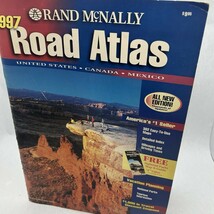
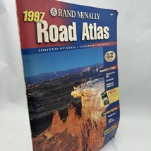
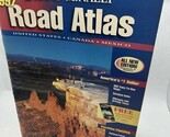
Road Atlas |
| Country: |
Canada |
| Publication Year: |
1997 |
| Country/Region of Manufacture: |
Mexico |
| Publication Name: |
Road Atlas 1997 |
| Author: |
Rand McNally |
| Region: |
United States |
| Publisher: |
Rand McNally |
Detalles del anuncio
| Las políticas del vendedor: | |
|---|---|
| Envío de descuento: |
Pesos de envío de todos los elementos se suman para el ahorro. |
| Publicado en venta: |
Más de una semana |
| Artículo número: |
1751939644 |
Descripción del Artículo
The most trusted and best-selling US atlas on the market made portable!. This updated North American atlas contains maps of every U.S. state and Canadian province, an overview map of Mexico, plus detailed maps of over 50 North American cities, all conveniently packaged for travel. Contains mileage chart showing distances between 77 cities and national parks with driving times map.
Other Features
Best of the Road - Our editor s favorite road trips from our Best of the Road collection follows scenic routes along stretches of coastline, both east and west, to forests mountains, and prairies; and through small towns and big cities. For a weekend or a week there s something for everyone.
Road construction and conditions phone numbers and websites
Tourism phone numbers and websites
Hotel phone numbers and websites
Shipped the next business day
6/2/25
Added to your wish list!
- Rand McNally Road Atlas 1997 [paperback] Rand McNally & Company
- 1 in stock
- Price negotiable
- Handling time 2 day.
- Returns/refunds accepted
Get an item reminder
We'll email you a link to your item now and follow up with a single reminder (if you'd like one). That's it! No spam, no hassle.
Already have an account?
Log in and add this item to your wish list.